Commodore Whitey Limes – April, 1980
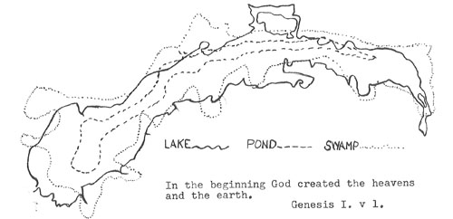
Actually what is now known as Buckeye Lake was formed by the gouging, grinding, and bulldozing effect of the last of the Ice Age glaciers.
A deep depression was left to the west of what is now known as Licking Hills. Into this depression flowed the waters of the melting ice and snow from the melting glacier. This created the infant Buckeye Lake.
The prehistoric Indians found Buckeye Lake beside a trail that they used traveling between the Ohio River and Lake Erie. They called it Big Pond. The swampy, marshy area around Big Pond, they called Big Swamp. It made an ideal spot for the Indians to rest, find food in all forms of wild life, before portaging their canoes from Great Bend in the South Fork of the Licking River to Walnut Creek of the Scioto.
Twenty five years before the Revolution, in 1751, the Ohio Company appointed one, Christopher Gist, because he got along well with the Indians, to “Spy out the lands.” He was the first white man in the lake area. While en route, Gist stopped long enough in Coshocton to hold the first Christmas service in Ohio, for the white traders and Indians.
After the Revolutionary War, the new federal government appointed Elnathan Schofield, a surveyor, to lay the area around Big Pond out in plats of 640 acres each. These plats were used to pay the Canadian veterans of the war against the British. At that time the Pond was five miles long, and between four and five hundred yards wide. These plats are shown on a map , made and signed by Schofield in 1801. This map was found in the basement of the Statehouse in Columbus, Ohio in 1910.
(Editor’s Note: Schoefield’s map was reproduced in 1910 by A.H. Sawyer, a draftsman with the State Board of Public Works. Sawyer’s maps are reproduced in A Story of Buckeye Lake by Joseph Simpson, also available on the website. LINK)
The present shoreline of Buckeye Lake roughly follows the border of the Big Swamp. The present form of the lake resembles the contour of the Big Pond.
In the early 1800’s, the only means of transportation, to and from the markets was by horseback, backpack, and canoes over trails of the Red man. One such trail was near the west end of the Big Pond.
Any development of proper transportation facilities at that time was physically and economically impossible. Add to this, the problems of the pending and resulting War of 1812.
The completion of the Erie Canal in 1823 was a ray of light for the people in and around the Big Pond.
In February 1825, after two years of consultation, the General Assembly of Ohio passed a resolution authorizing the construction of two canals in Ohio. One of these canals would be near the end of the Big Pond.
On 4 July 1825, the first spade full of earth was turned over at the spot now marked by a stone monument and part of the remains of “Taylor’s Locks” on Rt. 79. This was the start of the canal.
The need for the storage of “Locking Water” required the raising of the level of the Big Pond. This was accomplished by building an embankment at the west end of the Big Pond extending from Seller’s Point to Sunfish Point by way of Onion and Fisher’s Islands.
In 1830, five years after the first spade of earth had been turned over at Licking Summit, the Big Pond was filled and ready to life canal craft over the Licking Scioto divide. At that time Big Pond became known as the Licking Summit Reservoir.
The rapid increase of the size of the canal fleet soon proved that the existing reservoir was inadequate to supply the necessary water. So an additional reservoir was created. This was done by putting up a new embankment west of the old reservoir, creating a new reservoir of about 500 acres. This new area is now known as the “New Lake” as shown on the chart of the lake in Gob’s Mess at BLYC.
The lack of maintenance during the Civil War days, the ravages of time and the coming of the railroads to the lake area soon reduced the canal traffic to the extent that it was no longer profitable.
In 1894, the General Assembly of Ohio “reserved Licking Summit Reservoir” for a public park to be known as “Buckeye Lake”. Hence the name Buckeye Lake.
Over the years, eons, ages or whatever you wish to call the passing of time, many changes have been made on, in and around Buckeye Lake. One of the strongest forces in maintaining Buckeye Lake’s high level in the resort class is Buckeye Lake Yacht Club , in spite of many disturbing outside forces.